 Kaid Benfield Archive
 Best-laid plans: Ontario gets it right on growth

Posted November 1, 2007 at 3:22PM
I’ve been mulling whether or not to post this particular blog entry because, truth to tell, it’s a little wonky and abstract compared to its predecessors. But it’s a great story that needs to be spread.
In particular, ours is a growing country. Not everyone may like that, but it is happening. As a result, it doesn’t work simply to oppose development. All that does is channel the growth to the places that complain the least, which in many cases may be forests or cornfields. As the old saw goes, the reason developers build in the countryside is “because cows and corn don’t come to public hearings.” The result of always saying no is only more sprawl, more pollution, and more of all the things we hate.
 The only constructive environmental response is to manage growth, and channel it to the places where it minimizes per-capita environmental impacts or, even better, to places, like distressed inner cities, that would benefit from more investment, jobs and people.
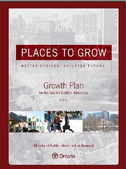
That is exactly what the growth plan for the region of Ontario surrounding Toronto, the “Greater Golden Horseshoe,” does. Canada is a growing country, too, and it now can boast the best land-use plan I have ever seen.
The Horseshoe, a region about the size of New Hampshire in area, is forecast to grow by 3.7 million people and 1.8 million jobs by 2031. It is already home to a quarter of Canada’s population and will soon be the third-largest urban region in North America. Imagine the consequences if development is allowed to spread all over the land, without good planning. Imagine the lost landscape, the additional roads and traffic, the pollution, the lost habitat, the global warming emissions.
 Thanks to Ontario’s foresighted government, that won’t happen. Instead, the most important urban region in Canada is likely to grow in a relatively compact, orderly manner that, compared to unchecked sprawl, will reduce pollution, conserve natural and financial resources, and save land.
In particular, the 25-year Places to Grow plan protects the environment by avoiding sprawl and channeling growth to places that already have or can accommodate the infrastructure to handle it. It plans for a variety of types of communities for residents to choose. And it saves land. Here’s how:
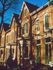
- By 2015, a minimum of 40 percent of new residential growth in each municipality must occur not on what is now forest or farmland but within existing cities and towns, via such measures as building on vacant parcels, converting brownfields and grayfields to new uses, and redeveloping obsolete properties.
- The plan places special emphasis on downtowns, transit corridors, and “major transit station areas.” Downtown areas, in particular, must strive to accommodate about 90 residents and/or jobs per acre by 2031, with highly urban Toronto’s target set at twice that amount.
- The plan recognizes that not all growth can occur in existing communities, and municipalities may also go through a process to designate greenfield areas for development. But greenfield development, when it occurs, must create complete communities, with development configurations and streets that support transit services, walking, biking, parks, and a mix of housing and jobs. And it must be built to a scale that makes efficient use of land, accommodating a minimum of about 20 residents and jobs per acre.
- All growth areas must accommodate affordable housing.
- Development generally may not occur outside of the designated areas. Areas important to natural resources or the environment must be protected, and there are restrictions on development of prime farmland.
- To support the plan, the government hopes to provide $8 billion in public transit investments and other necessary infrastructure over five years.
We know from a large body of research that growing in a compact rather than sprawling pattern will reduce driving, and associated carbon and other emissions, compared to sprawl. As a general rule, compact development will reduce driving 20-40% compared to sprawl, depending on circumstances. It can also reduce stormwater runoff by a comparable or greater amount per capita. In this context, Places to Grow already represents a huge triumph for the environment. But the story doesn’t end there.
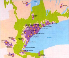 Perhaps the greatest, and certainly the most visible, contribution of the new plan is that it will allow the continued protection of a greenbelt comprising 1.8 million acres of rural and conservation land. Check out the map image of the Horseshoe just to the left. The large purple area is Toronto and its immediate suburbs; the large blue area is Lake Ontario. And everything you see in green on the map will remain green on the ground. (At least when there’s no snow.) More than anything, this illustrates the potential of smart growth: if we allow our existing communities to develop, and we build to a compact, walkable scale, we can save the countryside. I attended a meeting once when former US EPA administrator Christine Todd Whitman said, “For every acre we are able to develop or redevelop in town, we can save 4-5 acres outside.” That potential is being made real in Ontario.
And wait, it gets even better. Places to Grow has the full force and effect of law, thanks to Ontario’s Places to Grow Act of 2005. 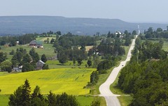 That law requires that local planning decisions, including zoning, conform to the policies in the regional plan. If there is a discrepancy, the provincial government has the authority to amend municipal decisions.
Major transgressions are unlikely, because of all the groundwork that has been laid for the plan. The process began six years ago, with the convening of a “smart growth panel” comprising representatives from municipalities, the development industry, environmental groups, and the academy. That panel’s recommendations led to the first draft growth plan, in 2004, and a series of revised drafts, multi-stakeholder workshops, public meetings and one-on-one meetings with key municipal and civic leaders. Places to Grow wasn’t handed down from above so much as jointly constructed by its stakeholders. They got it right.