 Kaid Benfield Archive
 The coolest spots for neighborhood development

Posted December 14, 2007 at 9:16PM
Neighborhoods can be cool in more ways than one. We are on the verge of a neat new technology that can identify the particular places within a metropolitan area that have the smallest global-warming footprint.
In a previous entry I mentioned my friend Eliot Allen, who does GIS-based planning from his firm, Criterion, in Portland, Oregon. Criterion exhibits many impressive skills, and one particularly impressive one is assisting municipalities and others in sophisticated regional mapping to help them determine the best places for land development, as well as the places to stay away from.
Lately, like a lot of us, Eliot and his firm have been thinking about how all this ability to compile data-based maps can help us reduce per-capita emissions of greenhouse gases. And, with a little bit of help from NRDC, Criterion is working on a concept Eliot calls Cool Spots, where land use, transportation and energy data converge to create the best places for low-carbon development.
It works in a step-by-step process, like this:
- Collect and import data in the region concerning energy usage and carbon dioxide emissions from building and transportation sources, delineated by location;
- Scan the region’s transit routes and service information, identifying stations, stops, and corridors;
- Map the area within comfortable walking distance of each transit node and corridor, as well as within walking distance of key neighborhood services such as food stores and parks.
- Combine the information to suggest places for improvements in increasing the availability of transportation choices, as well as improvements in building and infrastructure energy efficiencies, within key walkable areas;
- Implement them to attract new smart-growth development to the right places and make cool spots even cooler with logical neighborhood design.
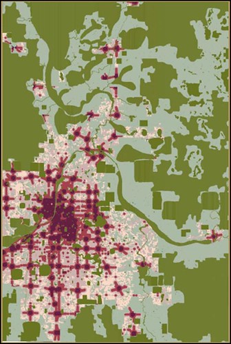 You can get an idea of how this might work by looking at this map of Grand Rapids, Michigan. The areas in dark green represent land that either has been or should be set aside for conservation or agriculture rather than development. The lighter green areas are mostly rural land that is in parcels too small for legal conservation but that have been determined to be not needed for development within the next 25 years.
The purple areas are the cool spots, where conditions are most environmentally favorable for development because of transit and walking conditions. This is where infrastructure investment and residential and commercial development should go to minimize the global warming impact of new growth. This map represents the good work of Jay Hoekstra of the Green Valley (MI) Metro Council, who enlisted Criterion to help with planning for the region.
Eliot estimates that, by taking advantage of the opportunities presented in these places, CO2 emissions per capita can be cut in half in as few as three years for the residents and workers who inhabit them. Now that’s cool.