 Kaid Benfield Archive
 Another lesson from les bastides

Posted February 13, 2008 at 9:35PM
 In my post yesterday on les bastides - the well-planned medieval towns in France, I mentioned that their town walls could be seen as a precursor to the gated McMansion "communities" that we see in suburban America today. Indeed, the word bastide in French is closely related to bastille and bastion, referring to fortifications.
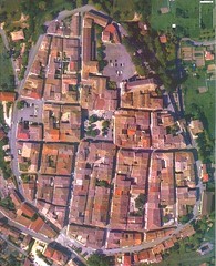
But those walls can also be seen as a precursor to something much better and more helpful to smart growth: growth boundaries, separating rural land from from developed cities and towns. Look, for instance, at the aerial photo of the bastide Monflanquin, located like Monpazier in the Dordogne region of southwestern France. Although the scale of the photo is limited, you can sense a clear demarcation between the town and the rural land outside it:
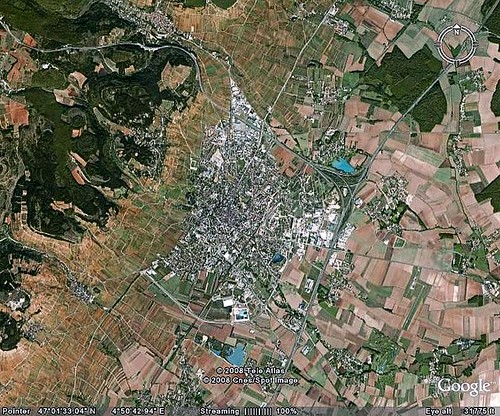
In Europe, this separation between rural and developed land has happened naturally, in an older culture that places more limits on land development and has always valued walkable densities. While it would be extremely naive to pretend that sprawl doesn't exist, or that there aren't places where that demarcation is fragmented badly, it's not nearly as prevalent as here in the US. Look, for instance, at the city of Beaune, located in France's Bourgogne (Burgundy) region and pictured below. It is easy to tell where the city ends and the countryside begins:
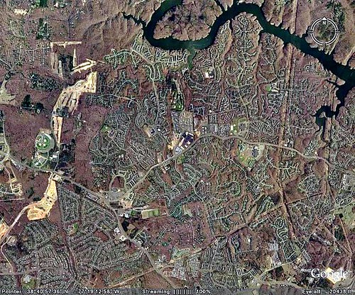
In the US, more and more regions are adopting growth boundaries to establish similar distinctions here, controlling sprawl by directing growth inward while conserving land outside the boundaries for rural uses. We have a long way to go, as the image below of Prince William County, in Virginia outside of Washington, DC, illustrates. Our development "pattern" is much more sprawling and haphazard than that of Beaune:
But the good news is that, where we have instituted growth boundaries, they have worked. The best known and most successful is the one around the suburbs of Portland, Oregon. Note the location of the growth boundary below, and the clear distinction between the developed suburb and the farmland outside:
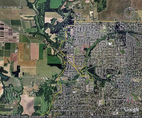
The practice is more advanced in Oregon than elsewhere because Oregon's land use laws were enacted in the 1970s. Portland, in particular, has taken them seriously, and probably has the country's best planning inside the boundary, too, but that's a story for another day.
I'll sign off by mentioning that the countryside around Beaune provides the best cycling I've ever experienced. Twice I've done week-long trips there, inn-to-inn and vineyard-to-vineyard. Beats an ice storm in DC, I'd say.