 Kaid Benfield Archive
 America’s most walkable cities and neighborhoods!

Posted July 17, 2008 at 6:40PM
Walk Score, the fab and fun folks who use Google Maps data to rate the walkability of locations and neighborhoods (my home address gets an 80 out of a possible 100) has done it again. This time they have ranked the 40 largest US cities and 2,508 neighborhoods within them.
Here is the honor roll of the top ten “most walkable” cities and their scores:
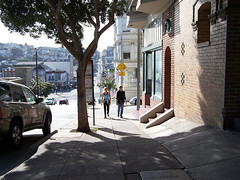
- San Francisco 86
- New York 83
- Boston 79
- Chicago 76
- Philadelphia 74
- Seattle 72
- Washington D.C. 70
- Long Beach 69
- Los Angeles 67
- Portland 66

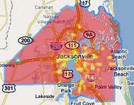
(Above, number 1 San Francisco and number 40 Jacksonville)
If you’re like me, you’re surprised to see Long Beach and Los Angeles on that list. Maybe we shouldn't be. I don’t know Long Beach (I’ve only driven through there, heh) but I know that LA does have some great walkable neighborhoods and is more compactly formed than a lot of people realize – in the city proper. One of the weaknesses of the Walk Score rankings is that, so far, they review and rank central cities only, not their suburbs and thus not their metropolitan areas.
Here are the five “least walkable”:
- Oklahoma City 43
- Indianapolis 42
- Charlotte 39
- Nashville 39
- Jacksonville 36
 Note that even the relatively unwalkable cities can have walkable neighborhoods within them. (Nashville’s Hillsboro, for instance, gets a 78. NRDC and Criterion Planners did research on Hillsboro several years ago, finding that its residents drive less than their more sprawling counterparts.)
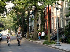
In fact, one of my favorite features of the rankings site is the list of 138 neighborhoods (“walkers’ paradises”) that score 90 or better on Walk Score’s criteria. Three neighborhoods, all in New York City and within walking distance of NRDC’s office there (Tribeca, Little Italy and Soho), score a perfect 100. DC’s Dupont Circle is among 17 neighborhoods that score 99.
Walk Score isn’t a perfect tool, because it doesn’t explicitly evaluate the directness or pedestrian-friendly character of walking routes. It also doesn’t include transit service among the walkers’ destinations that it values within convenient distance for pedestrians. But it is still a useful and fun one, a very handy general indicator of smart places, and I love what they are doing.
 In addition to its maps and scores, the site contains evaluative discussion by experts Alan Durning and Chris Leinberger, photo tours, an explanation of how its scores are derived, and side-by-side maps that illustrate the differences between walkable and unwalkable places. As Walk Score’s authors point out:
“The cities at the top of the Walk Score rankings have density, mixed use, transit, short blocks—and almost everything else on our walkability checklist. Most importantly, these cities have lots of destinations near each address, which is the strongest indicator of whether people walk.”
The site even includes a lobbying plug for good walking, cycling and transit features in the upcoming federal transportation bill. Do check out the site, and then think about what you like and don’t like about walking in your own neighborhood. These guys are my new heroes.