 Kaid Benfield Archive
 Linking the Chicago climate plan to the broader region

Posted October 2, 2008 at 2:28PM
Last week my NRDC colleague Josh Mogerman wrote a rave review of the City of Chicago's new climate action plan. Given the plan's apparent emphasis on efficient transportation, green building, and renewables, he won't get any argument from me.
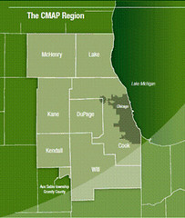
Now it's time to take that thinking and apply it to the region's growth patterns, especially in Chicago's surrounding "collar counties."
 There has been a lot of attention in the environmental world to the actions of big cities in addressing climate change, in part because of some high-profile environmental initiatives by big city mayors like Richard Daly in Chicago, Michael Bloomberg in New York, and their international counterparts. Unfortunately, there has been much less activity just outside big cities' borders, where we need it most. The suburbs and edge cities are where the most people live, where the most growth has been, and where the carbon emissions per capita are the highest (see my post last week on Portland for an illustration).
So doing something in Chicago the city is a start. But, in order to make a substantial difference in carbon emissions, we need climate action from Chicago the region. In fact, probably the most important thing the city could do for reducing greenhouse gas emissions is to absorb more of the region's projected growth, so less of it goes to the fringe where driving rates and carbon emissions can be several times greater than in the city. As far as I can tell, Chicago's climate plan is completely - and unfortunately - silent on that point.
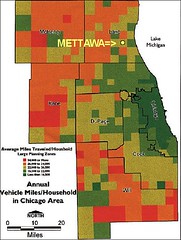
To the left below, see metro Chicago sprawling to the west, in all-too-typical disorganized fashion. To the right, see the variation in driving patterns (and thus in carbon emissions) across the region. Regular readers may recall that I have used this map before in this space: the locations in orange and red drive much more than those in green. The darkest green - the area that needs the least improvement per capita - is the city of Chicago:
On the plus side, the metropolitan region has an outstanding framework, vision, and process in place to shape how "Chicagoland" as a whole can develop sustainably. Beginning with The 2040 Regional Framework, regional planners earlier this decade anticipated growth of two million more people and over a million new jobs in the Chicago region and provided a blueprint for guiding that growth efficiently into city and town centers and transit corridors throughout the region, while protecting open space and farmland. Although not written explicitly to address climate concerns, the framework's effect would clearly minimize them by reducing driving per capita.
Conceived over a period of years in consultation with some 4000 civic leaders and citizens, the Framework was selected "best plan of the year" in 2006 by the American Planning Association. My friend Ron Thomas led that planning effort for the Northeastern Illinois Planning Commission (NIPC), and he should be very proud of the product.
The Framework's strategies include the following, among others:
- Encourage Redevelopment, Reuse and Infill
- Achieve a Balance Between Jobs and Housing
- Provide Affordable Housing
 Opportunities
 - Promote Livable Communities
- Promote Economic Vitality
- Promote Diversity and Inclusiveness
- Promote Compact, Mixed-use Development
- Promote Walking and Bicycling as Alternative Modes of Travel
- Maximize Use of Existing Infrastructure
- Protect Water Resources
- Enhance and Connect Green Areas
- Preserve Farmland
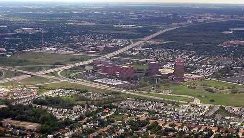
Greater Chicago does have good examples to emulate for creating smarter neighborhoods - from walkable conveniences like the Schaumberg farmers' market, above, to a row of historic houses in the city and a more traditional suburban downtown in otherwise-sprawling Naperville, below:


Since the Framework was released, NIPC was absorbed into a new agency, the Chicago Metropolitan Agency for Planning. CMAP formally adopted the Framework and recently released the next step, a "regional vision" called Go To 2040. The agency is again engaging the public and, by summer 2009, CMAP hopes to fashion the 2040 principles and vision into a comprehensive regional plan identifying specific steps, strategies, and investments necessary to achieve regional goals, including sustainability.
This is a major opportunity. Let's wish them well, because to fail would mean that increasing suburban carbon emissions could completely wipe out any gains in the city anticipated by the mayor's new action plan.
We also must bear in mind that plans, whether at the municipal or regional level, seldom have much in the way of teeth in the US. Realizing the sensible, farsighted goals of planning ultimately will be dependent on the will of the many municipalities and counties that make up the greater Chicago region to carry them out. (In other words, this isn't Toronto.) So very strong leadership is needed. In the city, the mayor seems up to the task. But where will it come from in the region?