 Kaid Benfield Archive
 Retrofitting suburbia for the 21st century (part 1: Tysons Corner update)

Posted October 7, 2008 at 2:07PM
It is becoming ever more clear that the suburbs of the current century cannot look or function like those of the late twentieth. Environmental and economic forces both are requiring that communities be more walkable, more transit-accessible, and more convenient than we have generally seen in the last 50 years. Increasingly, that means we must substantially retrofit the automobile-oriented suburbs of the past, and the Washington, DC region, where I live, is flush with examples. Three of them have long been national icons of suburban development.
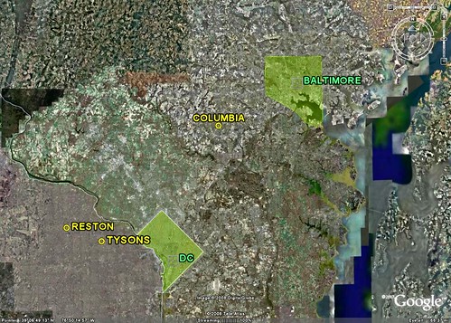
In particular, both Reston, Virginia, 20 miles to the west, and Columbia, Maryland, 36 miles to the northeast (and actually closer to Baltimore), were conceived in the 1960s and heralded as planned "new towns" that promised a new and better way of life on what had until then been only farmland Around the same time, the Tysons Corner Center opened 15 miles west of downtown DC as the largest enclosed mall in the world, on what had long been a modest rural crossroads. Although far less idealistic in intention than Reston and Columbia, the new mall spawned rampant commercial development on nearby land, and Tysons quickly grew into the most famous "edge city" in the country.
While doing justice to the smart redevelopment taking place in Tysons, Columbia and Reston cannot possibly be covered in the length of a blog post, I am going to introduce the subject and provide some links and references for interested readers.
(Incidentally, before Reston and Columbia, another idealistic "new town," Greenbelt, Maryland, just to the northeast of Washington, was built in the 1930s as a project of the New Deal. Greenbelt was designed as a self-sufficient cooperative community that would ease the pressing housing shortage near the nation's capital.)
The Tysons makeover
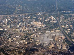
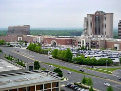
A few months ago I devoted a blog post to Tysons Corner, an absolute mess of a place that would be hard-pressed to function worse environmentally or even as a place to navigate in a car. You'd have to be suicidal to try it on foot. See below for what it looks like now. The photo on the right is actually flattering:
As I wrote in the earlier post, Tysons is destined to get four new Metro rail transit stations as one of the system's lines is extended to Dulles Airport, and it has been undergoing a lengthy and complex re-imagining process. About two weeks ago, the Tysons Land Use Task Force submitted its transportation and land use recommendations to the Fairfax County board of supervisors.
Under the plan, Tysons, already a "city" of over 100,000 people in the daytime (and fewer than 20,000 at night), and 167,000 parking spaces(!), will become a real city. There will be a substantial increase in residents, 95 percent of them within easy walking distance of one of the four planned Metro stations and with targets for affordable and workforce housing. The density will be highest at the stations, and tapered down to the edges of the redevelopment parcel in order to blend seamlessly with existing surrounding neighborhoods.
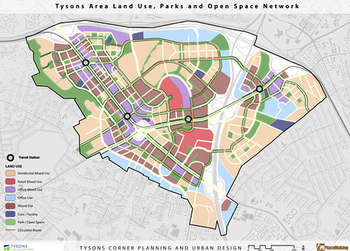
(Light blue above indicates planned office areas. Most areas are designated for mixed use, with red indicating primarily retail; purple indicates primarily offices; tan indicates primarily residential; and brown indicates an even mix.)
The nonsensical spaghetti of current roads will be replaced by tree-lined boulevards along the main routes and a walkable, fine grid of "complete streets" in the interior. Metro rail transit will be supplemented by interconnecting circulator and neighborhood buses. The goal is automobile independence and substantial reductions in vehicle travel per capita.
All buildings will have to meet LEED silver or equivalent green standards by 2013, with incentives provided for higher levels of "greenness." There will be sophisticated low-impact stormwater management systems designed to mimic forested conditions. 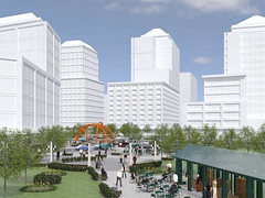 And, in an element that I believe is badly needed, there will be an extensive, mostly connected set of parks and other green spaces (all the areas in green in the land use plan above).
I do have one gripe: either the contemplated architecture is uninspired at best and possibly soul-deadening, or the Task Force (which received design and graphics assistance from PB Placemaking) really missed an opportunity to make their vision look lots more appealing to the county supervisors and the public.
Next: real downtowns for Columbia and Reston