 Kaid Benfield Archive
 Planning with Legos(r) – or, I may not like reality, but I love Reality Check

Posted March 13, 2009 at 1:27PM
Most of us love to gripe about development, traffic, and sprawl, and some of us even love to complain about the development activities of nearby churches and schools. But what if the same folks who complain had to confront a specified influx of residents and jobs (and it will keep happening, despite the recession), and had to make realistic decisions about how to accommodate that growth in their communities? What would they do then?
 It turns out that they make pretty good decisions, actually, if given all the relevant information. People may take ill-advised positions when allowed to confront growth only parcel by parcel, bit by bit. But, when given a chance to participate in the bigger-picture conversation, they come to an understanding of what the real choices are and, by and large, do pretty well.
That was the thinking behind Envision Utah, a voluminous exercise in participatory planning for growth in that state's Wasatch Valley (around Salt Lake City's region), begun in the 1990s. The process ended up changing the way Utah residents think about their region, the environment, and development, and it promises to change the results on the ground, too, from what they otherwise would have been.
And, that, in a nutshell, is also the philosophy behind Reality Check, a participatory visioning process being staged in metro regions around the country by the Urban Land Institute. 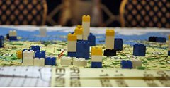 Over the last few years (each of these undertakings does require a substantial investment of time), ULI and various partners have staged Reality Check exercises on-site in metro Los Angeles, metro Washington, North Texas, the state of Maryland and, most recently, the Raleigh-Durham-Chapel Hill "Research Triangle" region of North Carolina.
The exact format has varied somewhat from place to place, but most involve the following:
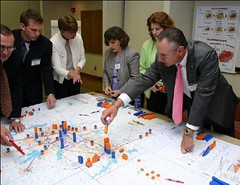
- Assembling a large and diverse group of stakeholders representing all relevant constituencies (300 of us in the one for metro DC a few years ago)
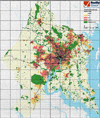
- Providing the group with large-scale, gridded maps of their region
- Providing basic information about the amount of growth in population and jobs expected in coming decades, along with related economic, transportation and environmental forces affecting the region
- Dividing the large group into tables of 8-10, each with a facilitator and computer whiz to keep track of their thinking and decisions
- Supplying a bunch of color-coded Legos(r) or stickers representing consistent numbers of expected new jobs and residents (e.g., each blue Lego might represent 1000 people, each yellow one 1000 jobs, etc.)
- Asking each table to select places on the map, if any, where participants think growth should not occur, and to allocate the new jobs and residents among the places where it should, along with accompanying infrastructure
 The process typically takes all morning, after which the tables report to the larger group. Sometimes there may be follow-up workshops and always there is a final report that is distributed to participants and local leaders.
While the exercise has no legal standing, it has tremendous educational value for participants and planners. And the participants then return to their constituencies with heightened awareness of the realistic issues facing their regions as well as, one hopes, new perspectives on how to meet the coming challenges.
Most tables learn right away that, if they allocate growth according to the current trend, there simply isn't enough room on the map for all the Legos(r). So they end up making thoughtful decisions, by and large (though there is always variation in the details among the tables). In the Research Triangle region, for example, 80 percent of the tables proposed a mass transit system linking the three core cities and the jobs-rich Research Triangle Park. In metro Washington, at every table, there was an increase in households near transit - "for some quite a lot," according to a summary presentation by cosponsor University of Maryland. At almost every table, participants also proposed an increase in jobs near transit. 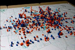 The percent of households inside the region's current development "envelope" remained constant at most tables at approximately 85 percent, meaning the trend toward increasing sprawl would be slowed.
I think two elements of the process are particularly important: First, participants must allocate all the expected jobs and residents. That's the "reality check" implied by the exercise's name. Second, the visioning is performed regionally. As ULI's thorough report on Reality Check points out, "political boundaries created 200 years ago have little relevance to the way people live, work, and play in the 21st century. Most of us cross county and even state lines several times a week as we commute to work, pick up our children at school, and go shopping on the weekend."
I love this process. None of us wants to see our communities screwed up, and all of us have a stake in their future. But we need to be realistic about it, too. Kudos to ULI for getting this going.