Rethinking environmental impacts to manage growth

Posted May 13, 2008 at 12:00PM
When faced with a situation where rapid growth is occurring, such as I discussed yesterday, the best thing to do environmentally is to manage and shape it so that a good quality of life is maintained with the least environmental harm. This is fundamentally about per capita, or per household, thinking: how can we shape the new development so that it has the least impact per increment of growth?
This is the essence of smart growth. But it also represents a fairly radical departure from traditional environmental thinking (and much of environmental law), which focuses our attention not on per capita impacts but on particular pieces of land, parcel-by-parcel.
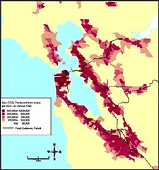
There are dramatic differences in the results of the two methods of thinking. Consider the two maps of the San Francisco Bay Area, below. The one on the left shows carbon dioxide emissions from cars, on a per-acre basis. The deeper the red, the greater the emissions. The one on the right shows the same emissions on a per-household basis:


The maps are practically opposite images of one another. Someone trying to plan how new development should be located, if not thinking in per capita terms, might look only at the map on the left, and conclude that development should avoid the more densely populated portions of the region, because of higher emissions there. The planner might also conclude that new development should be spread out, to avoid mimicking the apparent effect of density.
But it would be the worst thing to do. The map on the right shows that the densely populated areas actually have lower CO2 emission rates than the outlying areas, when considered on a per-household basis. Overall CO2 emissions in the atmosphere will be minimized if new development, to the greatest extent possible, locates within and mimics the more heavily settled areas. This is because people in denser, more central locations drive less.
You can make the same sorts of comparisons for other environmental media. Stormwater runoff, for example, is exacerbated by pavement, rooftops, and other impervious surfaces. Compare the two maps of Seattle below, which show per-acre impervious surface on the left, and per-capita impervious surface on the right. Again, the deeper the color, the greater the imperviousness:

Remember, the choice is not between growing and not growing. The choice is only about how and where. And what the maps show is that per-person incremental impacts of growth are minimized by density and central locations. In other words, for a given amount of growth, the way to reduce overall impervious surface in the larger watershed is to concentrate it in as few places as possible and keep the overall development footprint of the region as small as possible. The result will be increased per-acre runoff in some parts of the watershed, but it will also mean less runoff in the watershed as a whole. This is mostly because more compact neighborhoods require less pavement - fewer road miles and parking lots - to serve them, on a per-unit basis. For more on how compact, centrally located development can benefit watersheds compared to sprawl, see EPA's terrific research on the subject.
The CO2 maps of San Francisco come from NRDC’s longtime collaborator, the Center for Neighborhood Technology. And the impervious surface maps of Seattle come from another longtime collaborator, Criterion Planners.