Connected streets save lives, says new research

Posted February 6, 2009 at 2:05PM
A couple of months ago, my colleague Rachel Sohmer authored a very good post on this blog that illustrated the practical convenience that comes with well-connected neighborhood streets. Researchers have found that neighborhoods with more connections (and thus smaller blocks) reduce automobile use, too, by making walking easier and shortening driving distances.
Now there's even more good news: older neighborhoods with well-connected, grid-like street patterns are safer, too. This contradicts a widely held belief that cul-de-sac patterns are safer because they reduce traffic.
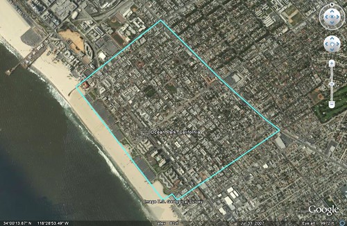
To visualize the difference, compare the two different patterns below. The older community of Ocean Park, California, is shown first, on top, and a newer subdivision in Irvine, California, is shown below it. Ocean Park has a traditional, highly connected street grid. The subdivision in Irvine is based on cul-de-sacs that connect to collector streets but not to each other:
In the latest issue of New Urban News, Philip Langdon reports on recently published findings by transportation researchers Wesley Marshall and Norman Garrick, who fed the facts from more than 130,000 vehicular crashes over a nine-year period in California into their computers:
"Their conclusion: The most unsafe cities in California, in terms of traffic fatalities, are the newest ones - those developed primarily since 1950. The cities with the fewest fatalities, by contrast, are those with significant portions built before 1950.
"The newer cities tend to have more "dendritic" networks - branching, tree-like organizations that include many cul-de-sacs, limiting the movement of traffic through residential areas. They also don't have as many intersections. The pre-1950 cities, on the other hand, tend to be more grid-like, giving motorists many more routes to choose from."
The University of Connecticut researchers also found that, of 24 medium-sized cities in California, the safer cities, on average, were twice as dense as the more dangerous cities (5,736 people per square mile, versus 2,673 per square mile), and also had significantly more intersections per square mile. The safer cities had only a third as many fatalities per capita as the more dangerous ones.
For example, the area within the boundary on the satellite photo of Ocean Park, on top above, has been measured at 316 intersections per square mile. The area within the boundary on the image of Irvine, below it, has been measured at only 8.7 intersections per square mile.
Intuition might lead us to expect Irvine to be the safer of the two neighborhoods. But, on a per capita basis, the opposite may well be true. For more, and a link to a slide presentation on the subject, go here.

