How a small community is becoming greener - with help from some important friends

Posted September 19, 2011 at 2:27PM
The small city of Ranson, West Virginia – population about 4000 – has taken some very important steps toward a more sustainable future. In particular, it is cleaning up its contaminated sites; reconceiving its streets and stormwater management; and encouraging walkable, in-town redevelopment, all at the same time. That Ranson had the initiative to do this is immensely significant, since we need more and better examples of green initiatives in small, rural communities. But just as significant is that none of this would be possible without the assistance of the federal government’s Partnership for Sustainable Communities.
The role of the federal Partnership
As many readers will know, the Partnership comprises the federal Departments of Transportation and Housing and Urban Development, along with the Environmental Protection Agency, all working together for healthier, more affordable, greener, and more economically secure neighborhoods, cities, and towns. It was launched two years ago.
The Partnership is under attack now in Congress, unfortunately, and criticized by some as the federal government intruding on local affairs. The Ranson case illustrates that nothing could be further from the truth. It was the local community leaders that initiated a request for federal assistance, not the government agencies swooping down from above. And it will be totally up to Ranson to take advantage of the innovative and impressive new planning that has been undertaken with federal assistance.
The assistance consists of several coordinated grants, which have been summarized in a White House blog post:
“In Ranson, the Partnership aligned planning grants and assistance from our three agencies to integrate affordable housing, economic development, and transportation to build a livable community. An EPA Brownfields Area-Wide Planning Grant will help Ranson prioritize cleanup of contaminated lots and develop reuse plans based on community input while EPA's Sustainable Communities Building Blocks assistance will help the city ensure that its development codes promote the kind of growth residents want. Using a DOT TIGER II Planning Grant, Ranson will create a Complete Street plan for the important Fairfax Boulevard / George Street corridor. This will ensure easy and safe downtown access for pedestrians and bicyclists as well as motorized vehicles. And a HUD Challenge Planning Grant will help Ranson develop a smart building code that encourages more compact, walkable development patterns.”
As it turns out, I have several friends working on the coordinated effort – called Ranson Renewed – both within government and in the planning firm PlaceMakers, one of the contractors retained to assist part of it. So I might be a little biased. But I also think most anyone who cares about these issues would be impressed with what’s been accomplished so far. I’ll say more about that in a minute but, first, a little context:
A bit about Ranson
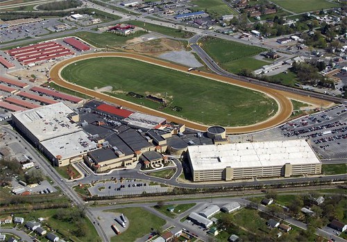
I can assure you that this is far from a radical or even liberal community. This is a town whose website features headlines like “July Yard and Brush Pick-up” and “Apple Valley Waste Route” - on the front page. It is adjacent to the Jefferson County seat, Charles Town, which has about the same number of residents but a more visible civic and commercial presence to its streets. And that’s pretty much it for Jefferson County’s “big cities.” The other major player is the Hollywood Casino at Charles Town Races, whose enormous site sits adjacent to both cities and employs 1,200 people.
Ranson prospered a century ago as a small industrial town but, today, the industrial legacy includes contaminated properties left behind when the plants eventually closed. According to its Wikipedia entry, “many of the homes date from the turn of the [20th] century and reflect styles of that era. Most are unassuming, vernacular, frame or brick, single family, two-story dwellings or one-story cottages.” Sprawl has been cropping up, especially along Route 9, which bypasses the town just to the east. Median household income is only half that of the US as a whole, and 25 percent of Ranson’s population lives below the poverty line.
Results of the planning effort
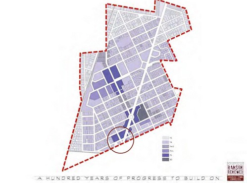
Pursuant to the HUD grant, PlaceMakers is recommending that Ranson adopt a “SmartCode” for zoning based on the new urbanist planning transect, which supplies design guidelines that differ for various areas planned to grow with different intensities of use. The basic transect has six zones, with T1 being the most rural and T6 being the most urban. The code places particular emphasis on walkability and how buildings address the street. The map just above shows the different transect zones proposed for Ranson. (Since Ranson is a small rural city, only one parcel is planned for T6.)
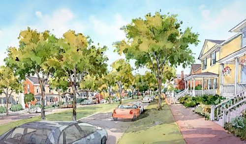
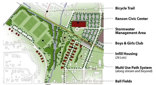
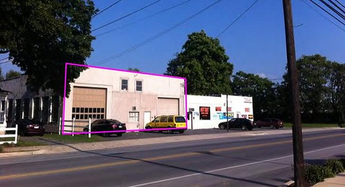
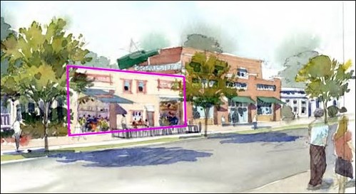
There is an emphasis on redevelopment and infill, which I like. See the images above for illustrative examples of how this might turn out. The plan for the contiguous developed area of Ranson makes logical sense to me.
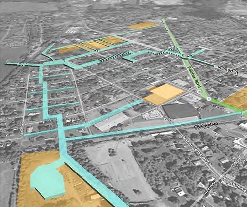
EPA’s grant was specifically for “a master plan for downtown Ranson that spurs job growth and economic development in former dilapidated manufacturing sites.” In this image, the orange parcels are brownfields designated for cleanup and redevelopment. The blue corridors are where public rights-of-way might be retrofitted with green infrastructure to filter stormwater instead of allowing it to run off as pollution into receiving waterways.
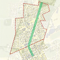
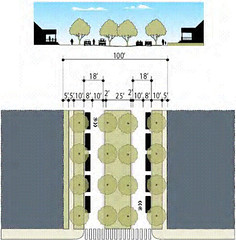
Planned with DOT funds, Fairfax Boulevard would become a designated “complete street” with both green infrastructure for stormwater and a slow design speed for motor vehicles, along with design to accommodate pedestrians and cyclists safely.
Also with DOT assistance, Historic Charles Washington Hall in adjacent Charles Town has been restored, with one section of it planned for adaptive reuse as a regional commuter center “that will facilitate access to regional rail and bus transit systems for Ranson, Charles Town and Jefferson County.”
Misgivings
I think all of that is pretty fabulous. But I don’t think the planning effort has been perfect.
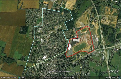
First, there’s an elephant in the room. The Hollywood Casino at Charles Town Races is the largest employer of residents of Ranson and Charles Town, and surely the county’s most significant economic engine. It is also a major, major landholder. Look above at the size and location of the casino/race track property, outlined in red, next to Ranson, outlined in blue. (Since I was drawing the boundary conservatively based on what is built, the gambling property's full tract may actually be larger.)
As noted, the facility employs 1200 people. It also draws three million visitors per year. According to its website:
“Hollywood Casino at Charles Town Races is a world-class entertainment venue featuring over 5,000 slot machines, 85 table games including Blackjack, Craps, Roulette, live poker, Mini-Baccarat and Pai Gow Poker, live entertainment, a wide range of food and beverage choices, and live and simulcast horse racing. The facility’s ¾ mile surface now attracts some of the East Coast’s best trainers, horses and jockeys.”
The racing is year-round, and the casino is open 24 hours per day, seven days per week. The facility also features "great dining to satisfy any hunger, including the all new Final Cut Steakhouse where you can savor prime cuts of steak, shopping outlets, and live entertainment."
Wouldn’t you think all this would have major implications for land use and transportation? Just about all significant new retail in recent years has located near the track and casino, for example, not in Ranson proper. The Casino’s parking garage alone is larger than any building in Ranson.
I have not read every word of every document posted on the Ranson Renewed website. But those that I did read, including a 100-slide summary presentation of the whole shebang and a background document called Ranson’s Economy, contain not one reference, not one, to the massive facility. It is as if it didn’t exist. (Surely it is discussed in one of the other background documents, at least, but I never found it.) If it were my money – and, come to think of it, it is – I would want the town’s planning to thoroughly analyze the effect of the casino and race track on the town and account for it. I’m not saying whether the gambling operation, on balance, is good or bad for the community, just that a planning exercise that ignores it risks being naïve.
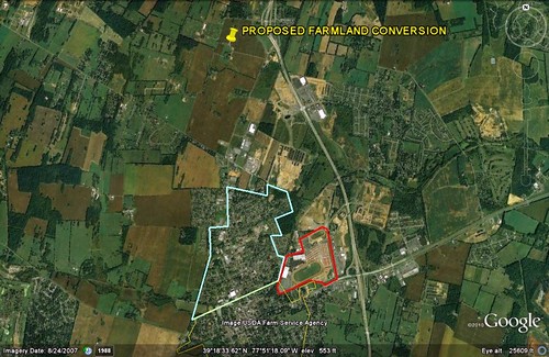
My second misgiving concerns the planners’ proposal to encourage leapfrog development on what is now farmland north of the city (see above). (Ranson went on an annexation spree a few years ago, so the parcel may be within the city limits now for all I know, but it is neither within nor contiguous to the currently developed area.) This is currently a farm owned by the Clayhill family. Under the proposal, some two-thirds to three-fourths of it will be irrevocably converted to residential (and a small bit of hoped-for commercial) use, with a green buffer around the developed portions, assuring that it will remain isolated from anything that develops nearby over the years.
The planners call the proposal for the Clayhill property “agrarian urbanism,” which is all the rage among a considerable wing of the Congress for the New Urbanism, of which I am a longstanding member and for which I was a volunteer for several years. I’m not a fan of the concept, which would sprinkle new development around what is now contiguous farmland, for the reasons I explained in detail here. 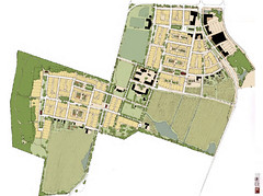 I believe it fragments agriculture, weakening it, and is certainly not “urban” in the vocabulary of anyone except those who support it. It also spreads development farther and farther out, creating a range of environmental problems. (If only Jefferson County had a "transfer of development rights" program, whereby owners of farmland like the Clayhills could sell the rights to develop their property to infill builders in parts of Ranson that would benefit from more density.) I suspect that here, though, it will generate high-end returns for the property owner and developer, which may be the real point.
That said, the folks who present it here and espouse the concept elsewhere are professional friends and people I respect a great deal. We agree on 80-90 percent of land use principles and I certainly endorse 80-90 percent of what they have proposed for Ranson. I just hope the Clayhill family and not HUD paid for this part of the planning. If HUD paid for it, the agency’s pledge to use location efficiency and the location standards of LEED for Neighborhood Development in its grantmaking are starting to ring hollow.
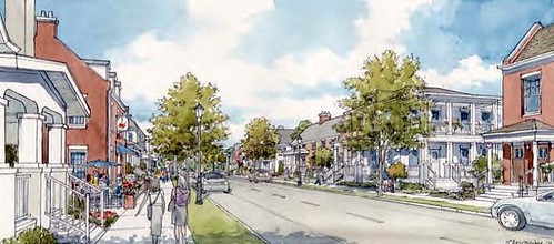
To close on a more upbeat note – because my feelings about what’s been happening in Ranson are far more positive than negative – here's an image of what the planners are proposing back in town, in the T4 zone:
In addition, you can go to the Ranson Renewed website and pick from several very good short videos about the project. Here’s one of them:
Move your cursor over the images for credit information.
