Reid Ewing on travel and the built environment

Posted July 2, 2010 at 1:38PM
On June 4, I posted a summary and link to the seminal ‘meta-analysis’ of published research on travel and the built environment, painstakingly researched and written by Professors Reid Ewing of the University of Utah and Robert Cervero of the University of California at Berkeley. That study synthesized the findings from nearly sixty separate studies of development and vehicle traffic, reaching a number of important conclusions that have profound implications for how we can best shape future development to minimize environmental harm.
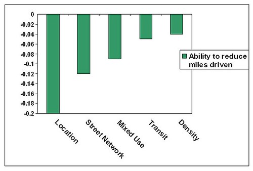
Central locations and well-connected street networks, in particular, were found to have the most potential to reduce driving and increase walking, respectively, with significant potential also from a diversity of neighborhood uses, access to public transportation, and good neighborhood density. In each case, the more the better for creating a sustainable neighborhood development.
A recent interview with study co-author Reid Ewing, conducted by Christina Hernandez and posted on SmartPlanet, adds interesting new perspective on the meta-analysis and its implications. Here are some excerpts:
“If California metropolitan areas, under their smart growth climate law, double the density of their regions over the next 20 years, what effect will that have on total vehicle miles and total emissions? Now there’s a convenient way of summarizing the effects. We can say with some certainty that if you double density you’ll get a five to 10 percent reduction in vehicle miles traveled.
“The best way to minimize driving appears to be to develop in existing centers near the core of the metropolitan area, in areas of high destination accessibility where there are a whole lot of jobs nearby. That’s the most important single factor.
“We found other factors like mixed-use and intersections and block size. They fall into a second group that is less important than destination accessibility, but are more important than density. Density turns out as less important than land-use mix where shops and schools and workplaces are near to people’s homes.
“If you’re trying to minimize vehicle miles traveled and maximize walking and transit, you’re better off emphasizing mixed-use and destination accessibility than just bumping up density. A dense development in the suburbs, far from transit and employment centers and stores, is probably not going to buy you much in the way of walking and transit use. Almost any development in the central city is going to be more efficient from a transportation standpoint.”
Of course, as some astute observers pointed out on in comments on my blog post last month, best of all is to employ all of these factors in synergy, increasing the environmental benefits and smart approaches far beyond what any single factor can do in isolation. In fact, one could argue that a combination of a central, accessible location; excellent street connectivity; a balanced mix of homes, jobs, shops and services; great transit service; and a critical mass of neighborhood density – representing each of the five factors highlighted in the meta-analysis – together form a pretty good working definition of a smart growth neighborhood.
Here’s more from Ewing:
“[High destination accessibility] means within easy driving distance of a lot of what are referred to as ‘trip attractions’ — shopping, employment, recreational facilities. These trip attractions are often measured by the number of jobs that you can reach by car in a given travel time. That’s the most important single variable. It’s correlated with the distance from the central business district. Generally the further out you go, the lower the destination accessibility . . .
“What we’ve been doing since World War II is promoting and encouraging urban sprawl. Urban sprawl has poor destination accessibility, low density, minimal diversity, poor design and great distance from transit.
“That’s what we’ve approved and actually encouraged by subsidizing sprawl. We should be promoting just the opposite of sprawl, which is dense, diverse, with high destination accessibility due to location within the region and with ready access to transit . . .
“Compact development is somewhat more expensive to do and it’s somewhat harder to do. Lenders are not as comfortable with mixed-use development. Traffic engineers tend to encourage development on the periphery on the urban area because that’s where there’s excess road capacity [ed. note: in part because of outmoded traffic forecasting models] . . . The importance of the study is that it will assist planners by allowing them to quantify the benefits of compact development.”
Many thanks to Hernandez and SmartPlanet for the interview, which you can read in full here.
Move your cursor over the images for credit information.
