Fixing sprawl with baby steps, one parking lot at a time

Posted September 27, 2012 at 1:28PM
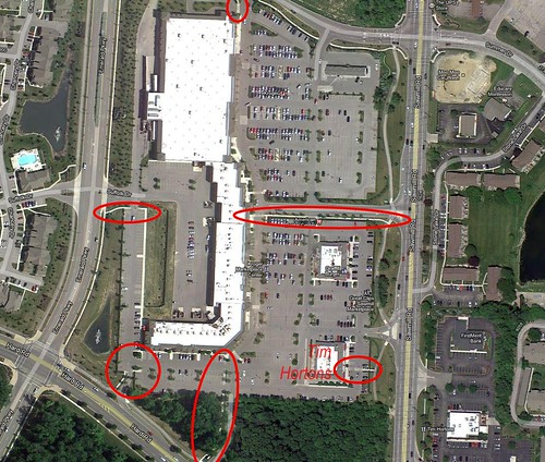
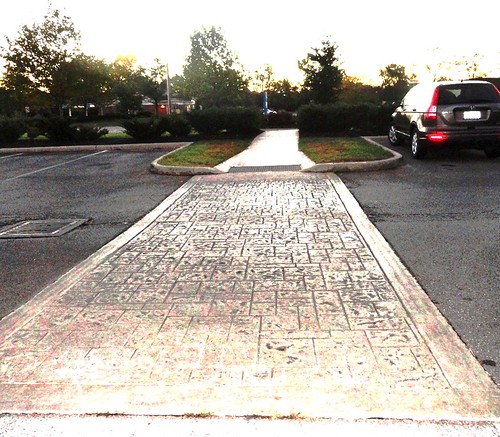
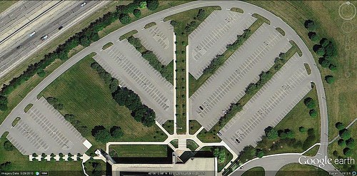
All credit to John Wirtz and his blog Xing Columbus for this one. It seems such a modest concept, really, and one that should have been standard practice long ago: put articulated pedestrian walkways to and within large suburban parking lots. This can get shoppers, workers and visitors more safely to and from their cars, and also facilitate the occasional pedestrian walking through the cars to get to a supermarket or shop more conveniently.
But, really, this could also be deceptively sophisticated. Take a closer look at the markings on the satellite image provided by Wirtz, and where they are placed. Intentionally or not, they are consistent with the beginnings of a street grid, potentially the first step in delineating the location of new streets and parcels, marking places for a more walkable system of blocks when the supersized parking lot is eventually redeveloped for something else. The walkways start to lay the foundation for a place with more connectivity and walkability.
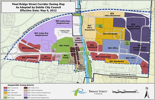
It could be a coincidence, but I’m betting not, that this is being done in Dublin, Ohio, an affluent suburb outside of Columbus that has committed to one of the most ambitious suburban retrofits anywhere. As I described in some detail two years ago, Dublin wants to become a more diverse, lively, and walkable community that can attract the best young workers to its several high-tech industries. Throughout the Bridge Street corridor, the closet thing Dublin has had to a main drag, the city is forging ahead with plans for better defined, walkable streets; compact and varied home choices to appeal to millennials and empty-nest baby boomers; new arts, entertainment, and shopping; and an upgraded park system. In short, Dublin hopes to move from a 20th-century suburb to one that can flourish in the 21st century.
While Wirtz's example lies outside the designated corridor, it is nearby; and great planning ideas can be contagious.
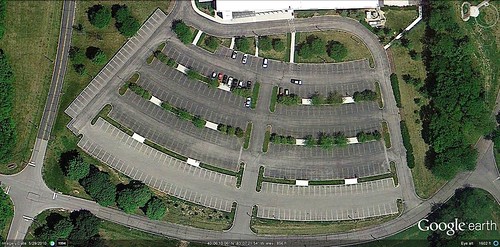
The Bridge Street corridor's retrofit will all be infill and redevelopment, slowing the spread of sprawl onto rural land. In fact, much of the redevelopment, especially in the early phases, is likely to take place within the target corridor on what are now giant corporate parking lots (see above), not all that different in scale from the one chosen by Wirtz to illustrate the new approach to walkways. I know of at least one advanced feasibility study being undertaken by a nationally-known development firm to help a large company in Dublin consider developing its surface parking lot.
Meanwhile, the city continues to do its part by updating its zoning code for the corridor with a hybrid form-based system, coupled with concurrent changes in the entitlement process. One of the planners who consulted on the zoning reform was Leslie Oberholtzer of Chicago’s Farr Associates, who reports:
“Not only is the [Corridor’s] vision a model for sustainability, but now the entitlement process Is, too. Don Elliott with Clarion Associates was the prime responsible for wrenching the approvals process . . . towards a more as-of-right administrative approval. My role was the development of the form standards. The incredibly talented (and numerous!) staff in Dublin were key throughout the process, pushing it through to adoption and revising the code along the way.”
Look to see more suburbs following Dublin’s lead in staying competitive by visioning and enabling the kind of development that appeals to young workers and residents, and helps the environment, too.
Related posts:
- How and why we should green parking facilities (March 29, 2012)
- How to retrofit failing suburban big-box stores into a green showcase (March 12, 2012)
- Can this dead suburban mall be transformed into something better? It's complicated. (June 13, 2011)
- Is it over for suburban corporate campuses? (May 31, 2011)
- Remaking a suburb for the creative class (October 21, 2010)
- For walkability and community, put the building on the street and the parking in back (April 20, 2010)
- Major real estate report: shift to urban living is “fundamental,” outer suburbs may “lack staying power” (November 10, 2009)
Move your cursor over the images for credit information.
